
John Tuttle, Paul Garrad and Linda Toich
Geological Survey Office, Queensland Department of Mines and Energy
Click here to download paper as a PDF
ABSTRACT
The Geological Survey Office (GSO) through its information assets plays a strategic role in developing and promoting the prospectivity and exploration potential of Queensland. GSO has benefited from digital technology in its data management and map production for over 15 years and has developed a high level of skill in the various data capture aspects relevant to geology. GSO and its support units have developed rigorous and effective data capture and integration strategies for field data including:
- A corporate digital geoscience data resource
- A structured approach to the capture of primary geoscience information
- An structured process for digital geological map compilation and production
- Ongoing capture of regional geophysical data over prospective terrains in Queensland
This corporate data framework guarantees that users have access to the most up to date geoscience data sets for project compilation and analysis.
The emphasis is now being placed on extracting and disseminating the information value of this data through prospectivity analysis, and new initiatives for the delivery of industry relevant digital geoscience information. The advent of desktop GIS systems has enabled the GSO to explore more accessible methods of disseminating digital geological information about Queensland including:
- A refocussing of geological projects to output data as GIS conformable structures
- Promotional GIS packages
- Mineral occurrence information packages and detailed project specific GIS packages containing seamless digital geological and related data
- Internet map server technology across the QDME intranet and eventually to the Internet
- Internet access to the open file geophysical data sets for Qld using GDADS (Geophysical Data Archiving and Distribution System)
- Digital company reporting and imaging of existing reports.
A continued focus on evolving the GIS and corporate database environments will enable QDME to take maximum advantage of the intranet/Internet as an information access and delivery strategy for local and global exploration and mining industry clients.
INTRODUCTION
The Geological Survey Office (GSO) has an objective of developing and promoting the prospectivity and exploration potential of Queensland. To meet this objective the GSO compiles, interprets and value adds to the State’s geoscience data and is the primary source and custodian for much of the Queensland Department of Mines and Energy (QMDE) geoscience knowledge and information resources. Geoscience information is a key commodity in the exploration and development of the State’s mineral and energy resources and an increasingly important component of the landuse decision making and policy development process. In this context, the custodians of that geoscience information have a responsibility to make it readily available to all stakeholders. It is critically important to deliver geoscience knowledge to external stakeholders to enhance Queensland’s ability to compete for exploration capital and to ensure the best-informed landuse decision making.
THE KNOWLEDGE FRAMEWORK
The conversion of geoscience data into knowledge is more achievable when that data is organised in an integrated management framework accessible to a range of analytical tools and information delivery mechanisms. Strategies to address this include the use of corporate databases and data structures, and the establishment of GIS based foundations that allow users to investigate the spatial information and application potential of the data.
The GSO has embraced these strategies in the establishment and ongoing development of a structured framework for its geoscience data. This is reflected in:
- A corporate, spatial geoscience data resource and ready access to all other relevant spatial data sets.
- Ongoing spatial geoscientific data capture with particular emphasis on the range of data attributes.
- A focus on data validation and data standards with attention to data accuracy, consistency and relevance to intended use.
- The creation of a development environment for GIS based project work separate from the structured MERLIN corporate environment.
- The introduction of PC based GIS software.
In turn, GSO is now placing more emphasis on unlocking the full knowledge contained in its geoscience data by embracing a range of application and information delivery initiatives including:
- The development of integrated project GIS data sets for analysis and anticipated release as GIS format data packages and the deployment of promotional GIS packages.
- The development of the QMIN system.
- The deployment of ArcView Internet Map Server and GDADS web map browsers as proof of concept projects at the intranet level for viewing and interrogating geoscience and related information.
- The allocation of funding to relocate the Department’s web page from an external service provider to within the Information Technology Branch in readiness for migrating geoscience focused web browsers to the Internet.
- The development of quantitative mineral potential and prospectivity analysis in a GIS framework.
- A proposal to develop a digital company reporting storage and management system.
The Geoscience Data Integration and Management Environment
Geological Survey geologists collect substantial amounts of geological and mineral occurrence data in the field, from company reports and via a range of image interpretation techniques. The key to the contained value of that data lies in translating the field data and observations into geoscience information that can influence the prospectivity and exploration potential of a region or contribute to the decision making process for landuse management in a region. Achieving these outcomes requires an integrated data environment with appropriate access and delivery mechanisms.
A range of software platforms including Oracle, Access, Intrepid, ER Mapper, ArcInfo, ArcView and MapInfo supports both the GSO’s data capture needs and its data manipulation and analytical requirements. Geological data are stored in the Geoscience and Resource Database (GRDB), a single Oracle database model structured as a series of systems – Surface Geology, Boreholes, Soil and Stream Sediment, Seismic Surveys, Aerial Geophysical Surveys (AGSS), Codes and Parameters and Bibliographic References. Data custodians along with test and development environments ensure that data and application integrity are maintained throughout the system modules. Geological maps are held as ArcInfo coverages tiled in an ArcInfo library system separate to GRDB.
Geoscience data collected from field observations, company reports and analytical procedures are entered directly to the relevant GRDB system via customized Oracle forms. Users can also query and view system data and perform data maintenance tasks via the same forms. The Surface Geology system is the core of the database for spatially related field data and stores geological, mine and whole rock geochemical data in a relational table structure. The rock units authority table in Codes and Parameters stores the names of all rock units in Queensland together with a unique identification key. GRDB data is interrogated or extracted either via Oracle Browser or direct ODBC links through Access, Excel or ArcView. Site related Surface Geology extracts can be formatted for mapping spatially as point feature themes in the relevant GIS system or for joining to digital geological map features via the relevant feature relate key. The rock units authority table provides the important linking mechanism to all associated descriptive attributes for geological unit data extracts with the unique unit key also being the feature relate item to digital geological map polygons.
Geological field mapping is transferred to compilation sheets, then digitally captured using ArcInfo. The capture process uses a departmental standard developed by the Graphical Services Unit with customized systems to automate relate item attributing for polygon and line features and for symbology. The ArcInfo data structure provides significant advantages in allowing all polygon and line features to be captured in the one data set with the major benefit being the creation of master digital geological maps for use in hard copy map production, the GIS user environment and as digital products. The digital geological maps are supplied to users as ArcInfo coverages with polygon and line feature relate keys that allow linking to feature attribute data. The coverages can also be translated to other GIS formats if required. The relate link makes available an increased range of feature attributes which in turn allows the theme based mapping and analytical capability of the map data to be greatly enhanced and ensures that the full value of field mapping data is available to the user.
Geophysical and satellite imagery is stored, managed and manipulated in a separate environment using Intrepid and ER Mapper software packages. The geophysical data environment is part of the corporate computer network that allows easy integration of geological data sets when required with output images for geological projects produced in a range of hard copy and digital formats.
THE APPLICATION ENVIRONMENT
Spatial information related activities principally use ESRI software accessing data from a single project development environment and the Oracle databases.
The GIS development environment is a framework for project activities consisting of network delivered GIS software and a large disk storage resource. Administrative and data custodial responsibilities including access and data read/write privileges have been set up to maintain environment integrity. Operating procedures have been developed for data storage emphasising standardised directory and file naming conventions to minimize data duplication. The standard directory structure also encourages a consistent product presentation at the completion of a project.
The GIS development environment provides project geologists with the capability to:
- Become involved in the validation phase of digital map compilation and to retrieve spatial geological data from Oracle tables for viewing, verification and analysis.
- Develop structured GIS project data sets.
- Respond to ad hoc enquires such as land use assessment.
- Experiment with quantitative resource assessment and mineral prospectivity modelling.
Derived data from GIS analysis and validation is returned to corporate data systems via defined custodial roles to ensure data quality and consistency. In addition, GIS applications have become one of the key tools to unlocking the contained information in GSO’s geoscience data. While the current gains have been beneficial for knowledge management and integration internally, a strong emphasis has now been placed on integration and transfer of our geoscience information to the exploration and mining industry.
This emphasis is reflected in:
- The creation of GIS project data sets, the development of promotional GIS packages based on ArcExplorer and the anticipated release of GIS format data packages.
- The development of more effective data access and management environments.
- The pilot testing and proposed implementation of web based map browser technology; and.
- The development of projects for resource assessment and mineral prospectivity analysis.
Project GIS Data Sets
The ability to compile integrated GIS data sets for display, manipulation and analysis has been one of the main outcomes of providing a GIS application environment for corporate geoscience data resources. The primary emphasis in GSO is on building project or region based data sets that are capable of delivering a range of outputs complimentary to the major mapping programs. To date advanced GIS projects have been developed for the Chillagoe-Palmer and Southeast Queensland Regions with the Yarrol, South Connors and Mt Isa Minerals projects next in line (Figure 1).
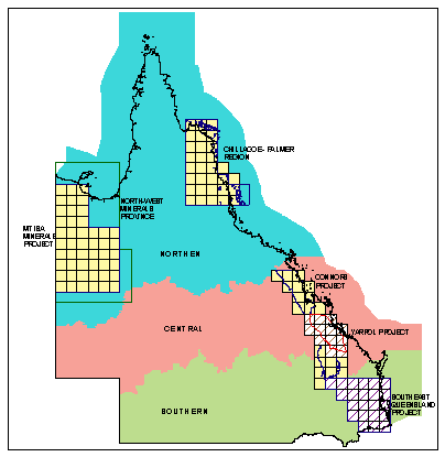
Figure 1. Location of Key Geological Survey Project Areas and QDME Regions
The regional GIS projects contain a range of geological and land use related themes underpinned by rigorously compiled digital geology with the emphasis on building where possible, a single seamless map at field compilation resolution. This map is supported by the addition of a large range of feature attributes to introduce multi theme capability to the underlying primary geology. Developing a single seamless geological map has proven to be a challenging process but the benefits are reflected in analytical capability, and consistent geological nomenclature throughout the geographic extent of a project area.
The Chillagoe-Palmer Region and South-East Queensland Project data sets will be the forerunners of a new range of information packages aimed at land use and resource assessment and highlighting the exploration potential of Queensland. However in the interim a promotional strategy has been put in place to highlight the availability to potential explorers of digital data sets in prospective regions. This involves using the freely available ESRI ArcExplorer browser and Adobe Acrobat Reader software products to provide at no cost, high level snapshots of available digital data sets – essentially a digital, spatial data catalogue. The North-west Queensland Minerals Province was the first release in this series and will be followed up by the Chillagoe-Palmer Region in late November. These data sets will be migrated to an Internet GIS environment once implemented.
The Queensland Mineral Resources Database (QMIN) Project
The QMIN project has the objective of compiling the resource information, production details, economic constraints and geological features of Queensland’s major mineral deposits. Once this data is compiled it will form the information basis to assist Resource Development Division (RDD) in responding to internal information demands and also assist in promotional activities to attract companies to explore and invest in Queensland. QMIN will deliver this information using a friendly, interactive, output focussed database and management interface to provide accurate, up to date data.
The system focuses on viewing and updating information associated with current, economically significant mineral resources that are either being mined or have the potential to be developed. It will provide improved advice on mineral sector activities and ensure that competing land use decisions are made with the full knowledge of current operations and the State’s mineral potential.
QMIN will utilise existing data infrastructure and introduce new technological initiatives. The implementation phase has three main components that are being progressed in parallel:
- Enhancement of existing Oracle GRDB systems and the creation of new data structures where necessary.
- Development of a user-friendly interface.
- Compilation of attribute and spatial resource information into the relevant corporate data Systems.
Significantly, QMIN (Figure 2) will take advantage of established data storage environments and current GIS technology, as the majority of the source data is associated with spatial entities. ArcView will be the primary software vehicle for compiling generic or specific data projects directly from the relevant databases, the project GIS environment and MERLIN graphics. However to meet the requirements of distributing this information to clients via a user-friendly interface, the web has been chosen as the ideal medium. This mode of distribution has been initially established on the QDME intranet using ESRI’s ArcView Internet Map Server (IMS) extension. Once performance, data and computer infrastructure issues are resolved this system will be rolled out to the Internet.
Figure 2. Diagrammatic Model of the Information Flow in the QMIN System.
It is planned to have the initial QMIN system generate three main outputs:
- Internet/intranet data views for browsing and general level decision making
- Report Views of the data
- Digital data for distribution in a simplified database and as an ArcExplorer GIS product.
The intranet and Internet
The decision by the QMIN project to flag the web as the ideal medium for displaying and distributing its spatial information (Figure 2) has had a flow on effect to the whole concept of GIS related data distribution in the department. As a result, ‘Proof of Concept’ projects have been initiated using ArcView IMS and software developed by Desmond Fitzgerald and Associates called Geographic Data Archiving and Distribution System (GDADS). Both projects have so far tested:
- The performance of the software in QDME’s IT environment using QDME data.
- The acceptability of the performance/response rate with QDME data.
- The ease of use of the software along with its capability for customising functionality.
The IMS project is up and running on the Department’s intranet (Figure 3) displaying views for Queensland’s Mineral Resources (Figure 4) and Petroleum Exploration Data, and geological and geophysical information for the North-west Queensland Minerals Province. Staff have been encouraged to visit the site and the interface continues to be customised based on users feed back.
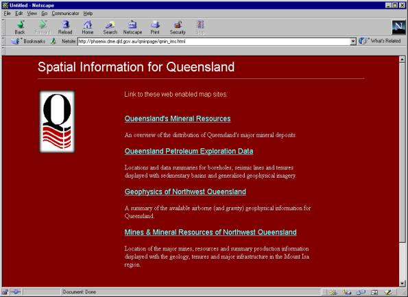
Figure 3. Entry Page for the ArcView Internet Map Server QMIN Views.
Figure 4. Internet Map Server View for Queensland’s Mineral Resources.
GDADS (Figure 5) is a Java-based web-aware archiving, query and ordering system for geo-located data using meta-data held within a relational database accessed via standard ODBC or JDBC type processes. This System provides the following capabilities (Fitzgerald and Associates 1998):
- Maintain archives and a catalogue of your surveys with acquisition, edit and access history, contents summary, storage location and security information,
- Maintain a user / customer database with security, access log and accounting information,
- Automate or semi-automate distribution of your data to users / customers using a combination of Intranet, Internet, electronic mail, FTP, CD–ROM and tape customised for your requirements. Your users / customers can use GDADS to query the survey catalogue and order copies of surveys from it.
Figure 5. Model for the GDADS System (Fitzgerald and Associates 1998).
GDADS has been installed on the QDME intranet (Figure 6) and is now being customised and populated with government, open range and open file geophysical survey details. This descriptive information (meta-data) about all aerial geophysical surveys in Queensland is contained in the Aerial Geophysical Survey System (AGSS) system, a sub-system of the MERLIN corporate database. Currently external clients seeking information about previous surveys must contact the system custodian to obtain the survey details. The GDADS interface, once fully implemented, will allow users to obtain meta-data about these surveys directly from the Internet and more importantly be able to view a thumbnail image of the survey. The required survey data can then be ordered from the appropriate agency with the ability to order selected data sets on-line also being evaluated.
The final step in the implementation phase of the IMS and GDADS projects will be their migration to the Internet. This is expected to occur by early 2000 on the basis of funding and technical resources allocated to relocate the Department’s web page from an external service provider to within the Information Technology Branch.
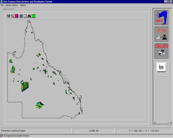
Figure 6. GDADS Web Based Interface Showing Thumbnail Images and Survey Area Outlines.
Mineral Prospectivity Assessments
GSO has recently commenced adapting a methodology using quantitative resource assessment and mineral prospectivity modelling to meet the requirements for promoting Queensland’s exploration potential. Research and modelling is carried out using the raster processing Spatial Analyst extension in ArcView with support from ER Mapper and ArcInfo for preparing some of the primary raster data sets. This type of analysis is receiving a high priority as a logical extension to GSO’s mineral and geological mapping roles and is made all the more easier as a result of the earlier commitments to corporately based data structures and formats, and to the established GIS environment. However, it has become apparent that there are certain data shortfalls that must be addressed in order to produce the most effective results, and these requirements are being factored back into the mapping and data gathering projects. The current development progress of our methodology will be addressed in another forum paper.
The Digital Company Report Project
A project proposal has been developed for migrating the company report system for mineral and coal to one that is more relevant to today’s technology driven environment. Based on that proposal, the Department has called for expressions of interest from potential suppliers for a system to manage digital company reports. The aim is to allow companies to lodge their exploration reports in digital format, and for the Department to be able to verify, process, catalogue and store these reports. The software will also be integrated with a retrieval and supply interface. The project will use agreed data standards for company reporting which consider the AMIRA Geoscience Data Model and the modified GGIPAC National Guidelines for the Submission of Mineral Exploration Reports on paper and in digital formats.
The system will satisfy the client need for a spatially and textually searchable report collection and will allow QDME to be more competitive for exploration investment, contribute to the preservation of the company report collection and act as a catalyst for upgrading information technology and management in the Department.
CONCLUSIONS
The commitment to a unified corporate approach to spatial and attribute data capture and storage is now returning dividends as GIS technology is more widely implemented. The Geological Survey’s work practices ensure that data gathered in its field mapping projects are integrated into the corporate data environment to emerge as the potential generators of geological information and knowledge.
The benefits of promoting this potential along with the GIS related technology at all levels of management and a more dynamic data user environment are reflected in:
- The development of new product types.
- The implementation of new data management and delivery strategies.
- The ability to respond to requests for specific or ad hoc data projects.
The new GIS development environment together with a growing appreciation of the technology’s applicability to project data management have also highlighted opportunities for evolving GRDB Systems. The current data exchange environment is far more dynamic as the emphasis shifts from data accumulation to data mining encouraging users to review the efficacy of the current data model.
Staff training and an emphasis on the application of GIS tools for analysing geological data has paved the way for a new generation of geological products from the GSO. The next stage will focus on building additional functional systems into the GIS and Oracle database environments that enable QDME to take maximum advantage of the intranet/Internet as an information access and delivery strategy for exploration and mining industry clients.
The successful implementation of web based map browsing will have ramifications for the way GSO currently conducts much of it spatial information business. The delivery of GIS based web developments to the Internet will be a final significant development, as it will open up the Geological Survey’s geoscience and related information to the global market and further the development of a range of web based information delivery tools.
REFERENCES
Fitzgerald, Desmond and Associates Pty Ltd, 1998. Intrepid Geophysical Software GDADS Geographical Data Archiving and Distribution Cookbook.
Garrad, P., Simpson, G. & Tuttle, J., 1999. A Review of GIS-based developments at the Queensland Department of Mines and Energy. Fourth National Forum on Information Management and GIS in the Geosciences. AGSO Record 1999/24.
Received: October 1999
Published: April 2000
AIG Journal Paper 2000-06, April 2000