
Margaretha Scott, Geological Survey Office, Queensland Department of Mines and Energy and the WH Bryan Mining Geology Research Centre, University of Queensland.
Click here to download paper as PDF
ABSTRACT
The Geological Survey Office (GSO) undertook a pilot study with the objective of assessing the ability of Survey data to support modern quantitative mineral potential modelling techniques. The Yarrol pilot project was designed to audit digital data sets routinely produced by the GSO, and to provide mineral assessment outputs relevant to both industry and Government decision-making processes. The study focused on the estimation of mineral potential using modern quantitative methods including the USGS three-part resource assessment methodology. Mineral potential was assessed for porphyry-copper-type deposits in part of the Yarrol Province, central Queensland establishing:
- ground permissive for the occurrence of copper-type porphyry deposits;
- zones favourable for the occurrence of such deposits using computer-based prospectivity modelling techniques; and
- estimates of the number of potential undiscovered deposits (probability of occurrence modelling). In this study the statistical technique ‘weights of evidence’ was used for prospectivity modelling in a general PC GIS software environment.The application processes used and the results of the Yarrol case study are reported in this paper, as well as the implications for the operations of the Geological Survey.
INTRODUCTION
Quantitative resource assessment methodology and computer-based mineral potential modelling techniques are fundamental techniques used in this study. Quantitative resource assessment is concerned with the probability of a mineral occurrence and in particular potentially economic resources. This assessment process is used to convert information about geology into economic terms. In this study the USGS quantitative three-part assessment methodology is followed. The USGS three-part quantitative approach to resource assessment is comprehensively described by Singer (1993). The methodology can be summarised briefly by considering the three component stages. Stage 1, is the delineation of permissive ground, and identifies areas where the geology permits the existence of deposits of one or more specific types as inferred by analogy with deposits in similar geological settings elsewhere. These areas, referred to as permissive tracts, are based on geological criteria derived from deposit models that are in turn based on studies of known deposits within and outside the study area. Stage 2, the estimation of the amount of metal and some ore characteristics, uses grade and tonnage models which are defined by deposit type. Grade and tonnage models are in the form of frequency distributions of tonnages and average grades of well-explored deposits of each type. This classification process is relevant because a major source of variation in size of deposits is accounted for by the differences in types of deposits (Cox and Singer, 1986). Grade and tonnage models are used to help define a deposit, as opposed to a mineral occurrence, and to provide the basis for estimating the potential value of undiscovered deposits in areas being assessed. Stage 3 involves estimating the number of undiscovered deposits. Estimates are made by deposit type and must be consistent with the grade and tonnage models, but, there are no fixed methods for making these estimates. Examples of methods that can be used singly or in combination include: frequency of deposits in well-explored areas (Allais, 1957; Bliss et al., 1987; and Bliss, 1992); extrapolations of local deposit density (Singer and MacKevett, 1977; Root et al., 1992); counting and assigning probabilities to anomalies and occurrences (Cox, 1993); process constraints (Drew and Menzie, 1993); and relative frequencies of related deposit types (Drew and Menzie, 1993).
The three-part methodology is used in this study because it incorporates information on geological uncertainty and ensures internal consistency between modelling stages. Most important to the current study, however, is the flexibility of this approach which can incorporate a range of information and modelling techniques. This flexibility is a key feature, helping to overcome practical issues that arise in implementing regional scale quantitative studies, for example: variations in the exploration history of regions; variations in the quality and quantity of data available; and restrictions in terms of the expertise and time available. It should be noted that no discovery model is involved in this methodology and that the estimates made of the undiscovered resources in-situ. No assumptions are made regarding exploitability.
This study differs from most assessments made using the USGS three-part methodology by incorporating computer-based prospectivity modelling. Applications used to combine and analyse data in the identification of prospective ground do not generally provide the probability of locating an ore deposit nor do they estimate the total number of undiscovered deposits in a region (exceptions include probabilistic neural networks and weights of evidence). They do, however, identify areas favourable for deposit occurrence, and therefore can be used as a guide in resource assessment, in much the same way that Drew and Menzie (1993) discuss the concept of ‘process constraints’. Prospectivity modelling is used here as a complementary technique to quantitative resource assessment, providing additional information supporting the estimation of the number of unknown deposits. There are a wide variety of methods that can be used in mineral prospectivity modelling, for example: expert systems such as fuzzy logic and the Dempster-Shafer belief theory; and statistical and pattern recognition systems such as regression and ‘weights of evidence’. New applications for the identification of prospective ground continue to be developed and trialed, such as neural networks (Singer and Kouda, 1996, 1997; Singer, in press) and geodynamic process modelling (Ord, 1999)[1] . Important in this study is not the selection of one particular prospectivity modelling method over another, but that whatever method or methods are applied, their limitations are recognised. ‘Weights of evidence’ is the technique used in this study.
The combined application of both computer-based prospectivity modelling and quantitative resource assessment is particularly relevant to the operations of Australian State Surveys because their primary objective is one of stimulating and focusing exploration activity with the ultimate goal being the discovery of economic deposits and the generation of State wealth. A secondary objective of the Surveys is to provide advice to Government to ensure effective resource management. The stages of quantitative resource assessment applied in this study, incorporating prospectivity modelling, provide a range of outputs suited to both government and exploration decision-making processes. Prospectivity modelling provides additional valuable information that can be used both for the marketing of State mineral potential and as an auditing tool for data sets provided by State Surveys to reduce perceptions of exploration risk and to increase exploration activity.
The following text is presented in three sections. The first section introduces the Yarrol study and briefly discusses the factors influencing the selection of the modelling techniques used. Also considered are geographic information systems (GIS) used as the modelling environment for spatial geoscientific data. The second section works through quantitative resource assessment and prospectivity modelling for the Yarrol case study. The third section discusses the results obtained in the preceding section and the implications of those results in terms of the operations of State Surveys.
SECTION 1 – THE YARROL STUDY
The primary objective of the Yarrol study is to audit Survey data in terms of its compatibility with and its completeness in terms of modern modelling techniques. Modifications to standard resource assessments have been made to suit the time and expertise available to this project. In a comprehensive resource assessment, all known and potential deposit models (those compatible with the geological environment) are used in the delineation phase to classify mineralised and barren environments and to classify the types of known deposits. The resource assessments made in this project, however, are directed at one of the deposit types that are already known to occur in the Yarrol region – porphyry systems. The following assessments are confined not only to porphyry type deposits and associated skarns, but also only to potential (or undiscovered) resources of this deposit type that may occur.
The Yarrol region is located in central Queensland south-west of Rockhampton (Figure 1). The area was selected because it is representative of the Surveys’ most recent ‘second-pass’ data acquisition operations. State geological surveys in general have, since the beginning of the 1990s, mapped project areas at 1:100 000 scale and have included in data capture airborne geophysical magnetic and radiometric data at 400m line spacing, as well as geological, structural and mineral occurrence data. Geochemical and regolith data are not a ‘standard’ data type captured by State Geological Surveys and was therefore not included in this study. Data sets include ‘raw’ data and ‘derived’ data. The latter is obtained by processing the original data into a form suitable for the definition of criteria relevant to the identification of ground permissive for porphyry style mineralisation as well as ground favourable for porphyry style mineralisation. The data used and the processing of these data are briefly discussed.
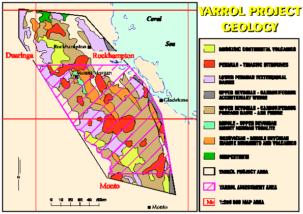
Figure 1. Yarrol Project Geology
Deposit occurrence information is commonly described in terms of the rock association (genetic or host association) and or the structural controls (fault, fold, igneous contacts). The genetic association between high-level granitoid intrusive rock units of Permian and Triassic age and porphyry copper type deposits, including copper skarns, in the Yarrol region is fundamental to the definition of permissive ground used in the Yarrol study. Plutons provide the heat or magmatic fluids involved in the mineralisation, but the latter may or may not involve structural controls. Locally deposits may occur at pluton margins or are closely associated with dykes and apophyses. The location of granitoid pluton margins is important for both prospectivity modelling and the definition of permissive ground. Margins must include the determination of the near surface, buried lateral extents of plutons, and this is done using geological maps in association with geophysical data. Digital geological data sets provide both visual ‘map’ displays and associated attribute data such as geological age and general rock descriptions.
Knowledge of the geographical distribution and geological characteristics of mineral deposits is also an important part of an analysis of resources. The presence of deposits confirms that specific ore-forming processes have occurred within the geological environments under study, and can also affect estimates of undiscovered deposits in the region (Singer, 1993a). Mineral occurrence information in digital format with attribute tables listing location, name and principal commodities, and classification of occurrences by deposit model was available for this study. Some of the occurrence sites are deposits and some are occurrences of porphyry or closely associated copper (and gold) skarn deposits [2]. Both deposit types are used recognising the continuum between copper porphyry and copper skarn deposits, although there are important grade and tonnage differences between members of this continuum (Cox and Singer, 1986).
Airborne radiometric data was collected using a standard 256 channel gamma-ray spectrometer at a flying height of approximately 80m. All data were sampled at 60-70m intervals on a survey grid flown with main lines normal to geological strike with 400m line spacing. Potassium was measured directly from gamma-ray photons emitted by 40K, uranium by 214Bi, and thorium by 208Tl. Airborne measurements were converted to ground concentrations following methods described by Grasty and Minty (1995). An additional radiometric data set was generated as a ratio of K/Th using ER-MAPPER software, and imported into Arcview 3.0 as a geo-referenced raster file from Arcinfo, gridded to 100m. The use of radiometric data is not extensive in this study as the field checked geological data sets had incorporated geological interpretations made from the radiometric data. Instead, the radiometric ratio data are used in later prospectivity modelling, to discriminate zones of alteration. Ratios of K/Th are used to eliminate the responses of Jurassic detrital material.
Airborne magnetic data had a sampling interval of 6-7m and flight line spacing of 400m. The data are used as geo-referenced raster files, resampled at 100m. Processing using ER-MAPPER software includes: reduction to the pole (effectively centering anomalies vertically above the feature concerned); generation of first vertical derivative (for edge enhancement and highlighting structure); and C-norm filtering (to reduce the effect of regional variation in values within a data set). Processed data sets are imported via Arcinfo into the Arcview 3.0 GIS with the Spatial Analyst extension enabling analysis of these raster data sets. Magnetic data are used for interpretations of granitoid rocks based on aeromagnetic signatures and extrapolation of these signatures to areas of either no exposure or no data. Deduction and inference based on the knowledge of the geology and basic principles of magnetic interpretation are used to sort out rock unit signatures. Extrapolation is used for the identification of other intrusive bodies including sub-surface ones. In the latter case, the shape of the anomaly depends in part on the depth to its source and was therefore also be used to infer depth to magnetic rock types. The lateral extent of magnetic plutonic bodies can also be interpreted from their associated magnetic signature using processed magnetic data to identify boundary features. Horizontal and vertical gradient processing is used to highlight non-horizontal boundaries between intrusives and rocks that have distinctly contrasting magnetic properties. These boundaries may represent faults, geological contacts, or abrupt limits to altered rocks. Magnetisation boundaries were also used in this study to supplement information on geological maps regarding intrusive bodies, their lateral extent, and their presence under cover. Magnetic interpretation of faults and linears are incorporated in the GIS and are used in prospectivity modelling.
The type, quantity, spatial distribution, and effectiveness of exploration information also need to be considered because of the impact this can have on the selection of prospectivity modelling techniques and on estimates of undiscovered deposits. Root et al., (1992) outlined that where exploration had been exhaustive and effective, estimates of undiscovered deposits may be zero and that where some exploration has occurred this may provide information about the tonnage distribution of known deposits and their spatial distribution. In the Yarrol region, exploration using modern techniques is far from comprehensive. However, there are areas such as Mount Morgan, with its world-class Au-Cu deposit, that have experienced intense exploration in recent times. The area around Mount Morgan has been explored for pluton related and hydrothermal/breccia deposits and this work has resulted in finds including Moonmera and Struck Oil. As a consequence of this exploration activity, the Mount Morgan region is used as a control in prospectivity modelling and in the estimation of the number of undiscovered deposits.
GIS is used in this study for modelling permissive and prospective ground. Separate GIS projects were developed for the Yarrol area and the Mount Morgan control area using Arcview 3.0 software (Environmental Systems Research Inc, 1996). The functionality required to analyse and integrate raster data sets was provided by the ‘Spatial Analyst’ extension (Environmental Systems Research Inc, 1997). Because of the disparity between the operational environment of standard GIS packages and that actually required to seriously model prospective ground, Arcview 3.0 and Spatial Analyst functionality were customised. A prototype extension was developed to provide a prospectivity analysis tool. The tool, designed to provide the analysis of the data-driven ‘weights of evidence’ technique handles raster and vector data sets and provides results of analyses as tables and visual displays.
SECTION 2 – MODELLING YARROL DATA
The Identification of Permissive Ground
Boundaries of permissive tracts or ground are defined such that the probability of deposits of the type delineated occurring outside the boundary is negligible based on the geology, knowledge about exhaustion of discovery possibilities through exploration, or through burial (Cox et al., 1996). Cover is an important condition affecting the viability of mineral resources with the depth of cover affecting:
- the chance of discovery, with deeper deposits much more difficult and costly to discover; and
- the economic viability, because deeper deposits are significantly more costly to mine.Permissive ground is identified by information about the deposit type being sought, considering examples from other similar geological settings and from the area of interest. The identification of permissive ground in the Yarrol study was based on the association of porphyry deposits and skarns with intrusive bodies and proximal to intrusive contacts. A known association between Permian-Triassic intrusives and porphyry-style mineralisation in the Yarrol region (Horton, 1982) was not used because of the chance of misclassification or exception. Instead a more general rule was used to define the permissive ground, that being the area of exposed intrusive outcrop plus an area extending 1000m outwards. Also included are areas where the presence of geophysical signatures or skarn indicates the subsurface presence of an intrusive body. A depth limitation of 300m was imposed for this study. Figure 2 shows the area identified as permissive ground.
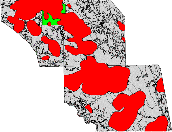
Figure 2. Areas idedntified as permissive ground
The Identification of Prospective Ground – Application of Weights of Evidence
The inclusion of prospectivity modelling as part of resource assessment requires: the development of a conceptual model; processing of data sets and related computer programming; and in this instance the generation and testing of predictor or ‘factor’ coverages. The gains associated with this modelling are the documentation of a systematic interpretation of prospectivity that is readily reproducible, and that this modelling can be used to support later stages of the resource assessment process, namely the estimation of the number of undiscovered deposits and in turn the estimation of resources. For Australian Surveys this process also serves as an audit of data sets aimed at impacting on the principal client group, the exploration industry, and provides an output that can be applied to the marketing of State resources. This section briefly introduces the modelling technique ‘weights of evidence’ and discusses its application to the Mount Morgan control and Yarrol data sets including the development of the exploration or conceptual model for porphyry type copper deposits and derivation of predictor or factor maps.
‘Weights of Evidence’
‘Weights of evidence’ combines information to classify locations into those that are favourable or not favourable for a deposit occurrence. This method learns relationships used in the prediction from training data (in this study, using data from the Mount Morgan control area) that contain a number of measured attributes associated with a group of deposits and associated with barren cells or polygons. The advantages of this technique are that it is relatively straightforward, can define proximity information and regional patterns such as geophysical anomalies, and can handle the problem of missing data. As with any other modelling technique there are limitations, however, including the requirements of a suitable training data set, the use of conceptual models based on well-explored deposits (an issue here is the limited number of deposits represent examples discovered under cover), and the problem of upward bias where posterior probabilities rather than rank weightings are sought (Singer, in press).
Weights of Evidence uses a form of Bayes rule:
P(D/Bj)=P(DÇBj)/P(Bj)
where P(D/Bj) is the conditional probability of a deposit given the presence of the j-th binary pattern. This equation can be redefined such that the conditional (posterior) probability of a deposit, given the presence of the binary pattern, equals the prior probability of the deposit P(D) multiplied by the factor P(Bj/D)/P(Bj):
P(D/Bj)=[P(Bj/D)P(D)]/P(Bj)
This model can be expressed in an ‘odds’ form, with ‘weights of evidence’ using the natural logarithm of odds. A fundamental assumption of the application of Bayes rule is that the conditional probabilities entering the equation are independent of each other. If this is not the case the resultant estimated probabilities are biased. In this method the strength of the association between the variable and known deposits is expressed as the difference between the weights – referred to as the contrast. The strength of this association measure can be used to determine the ‘optimum’ distance to a specific feature by establishing the distance from the feature having the highest area-cumulative contrast.
Applying ‘Weights of Evidence’ in the Yarrol Study
In the Yarrol study the first step was to develop a conceptual or exploration model. Conceptual models are basically used to focus mineral potential modelling. These models are based on the deposit model applicable to the deposit type of interest, however, they are composed of criteria relevant to the data sets to be used. The purpose of the conceptual model here, where data are a given, is to identify what is relevant within the information available in terms of the target sought. The conceptual model guides the selection of predictive patterns or ‘factors’ as well as the operations to extract this information. The conceptual model developed for this study was based on general deposit models of porphyry copper deposits and characteristics of deposits known in the Yarrol Province. Six exploration criteria were identified that reflected the regional nature of the information used in this study. These criteria were: heat source; age of mineralisation; rock type; structural associations; ore mineralogy; and alteration mineralogy.
The next step required establishing the relevance of the six exploration criteria/predictors by isolating and extracting, weighting, and ranking these factors. This process began with the conversion of multiclass maps into more robust binary maps by the processes of map reclassification, generation of proximity maps, and processing and reclassification of raster magnetic and radiometric data sets. Map reclassification involved the selection of critical lithological units, for example by age, composition and or rock type. The generation of proximity maps is the process whereby the optimal distance to a specific feature is identified, for example the distance to faults of a particular orientation or distance to intrusive contacts. Processing and reclassification of raster magnetic and radiometric data sets was used to identify areas with anomalously high and or low values. The first two processes were used to reclassify existing data sets for the targeting of porphyry copper deposits based on the three factors identified in the conceptual model: proximity to heat source, rock type, and proximity to structural controls. The third process uses characteristic geophysical signatures to identify areas of alteration and ore mineralogy that are suggestive of porphyry copper mineralisation. The Arcview ‘weights of evidence’ extension provided two analysis options: cumulative or non-cumulative. Factors that are spatially linked require the determination of an optimal distance from a feature, and use the cumulative option. A cut-off value is determined by plotting the contrast measurement (C) as a function of cumulative distance and finding the distance at which C is at a maximum. Factors that have a direct association, such as rock type, use the non-cumulative option which selects for a particular feature and then calculates weight and posterior probabilities based on the deposit type sought. The Mount Morgan control area served as a training set with weights and posterior probabilities generated for a range of potential predictor patterns or factors. This information was subsequently used to identify significant factors and associated weights which were propagated for the entire study area using the ‘weights of evidence’ extension integration function.
Fertile heat sources were identified using the Mount Morgan control area by selecting Permian and Triassic age intrusives, and also those described as being of probable Permian age. Magnetic data available for both the Mount Morgan control area and the Yarrol databases were used to supplement geological data to delineate intrusive bodies and extensions hidden under cover. All concealed bodies under less than 300m of cover were considered potentially fertile. Areas favourable for porphyry type mineralisation are determined by generating successive proximity buffers using the ‘weights of evidence’ extension cumulative option. Horton (1982) identified granodiorite porphyry, quartz diorite porphyry and monzonite porphyry as being associated with higher-grade porphyry mineralisation in the study region [3] . Factor derivation involves reclassification of the geology data set by composition for example: diorite/quartz diorite and areas mapped as cover overlying diorite/quartz diorite bodies; carbonate-rich sediments/limestones; and synvolcanic dyke swarms. Only diorite and quartz diorite rock units were found to have a significant association with known deposits. Structural ore controls referred to in porphyry deposit models include stockwork veins and breccias. Regional mapping at 1:100 000 scale generally does not identify these sorts of criteria. However, Horton (1982) reported on associations with local and regional scale faults in the Yarrol region, and these features had been identified by using 1:100 000 scale maps that had been generated from aerial photography bases at 1:25 000 scale. Advice from exploration geologists familiar with the Yarrol region also suggested that major north-west and possibly north-east faults may be involved in the localisation of porphyry style deposits in the area. Information on regional and local faults/linears was extracted from the geological data set and also from interpretations of regional magnetic and gravity data sets. The ‘weights of evidence’ extension was used to calculate fault trends and to provide the option to make a selection from within a nominated range. Analysis of contrast values shows only north-west trending faults to have a significant association with known porphyry type mineralisation in the Mount Morgan control area. Plots of the contrast against distance showed an optimal cut-off of 100m for north-west trending faults .
Recognition of alteration is an important exploration tool for porphyry systems. Whilst alteration maps are not produced by the GSO or other State Geological Surveys, regional radiometric data are routinely acquired. Ratios of K:Th were used in this study to filter out responses from younger Jurassic sediments and to highlight areas of alteration. Porphyry ore zones, particularly those with higher Au content, are described in deposit models as being associated with magnetite-rich rocks and therefore appear as ‘highs’ in magnetic surveys. Alternatively, the more intense hydrothermally altered rocks produce magnetic lows. Lows may also be surrounded by an area of high magnetic response reflecting hornfelsed rocks surrounding an intrusive. Rather than arbitrarily assigning magnetic values as ‘high’ or ‘low’, actual values associated with known porphyry occurrences in the Mount Morgan control area were used. A problem with this approach, which compares values from one area with those recorded in another, is the effect of regional variation in geophysical data sets. A contrast normalisation filter (Fitzgerald and Associates, 1997) was used to reduce the effect of regional variation.
The prospectivity map generated using the preceding predictor data for the Mount Morgan control area is shown in Figure 3. Areas numbered (1) and (2) identified the main areas where porphyry style mineralisation is known to occur, including the Moonmera deposit. Not identified in this trial was the Struck Oil porphyry deposit (4). Struck Oil, a concealed prospect, has no surface search criteria and the magnetic response in this trial did not prove significant. Discrimination of concealed deposits clearly requires further research. Areas (3) and (5) also rated highly for prospectivity. Area (3) has no recorded porphyry style mineralisation, although a number of small gold prospects do occur nearby. This suggests that either the factor data sets generated have identified broad porphyry systems including associated epithermal activity, or that there has been a misclassification of the deposit styles in the mineral occurrence data sets that were used. Area (5) is located in close proximity to mineralisation known to occur on a north-west trending fault zone. The red lines in Figure 3 delineate areas identified as prospective by an expert geophysicist working with the magnetic data set for the GSO Yarrol Project. These prospective areas complement the results obtained through the ‘weight of evidence’ modelling. Area (6), did not rank as high as areas (1)-(5), and reflected a favourable magnetic response but there was an absence of any other evidence. The same steps that were used for the Mount Morgan control area were followed for the Yarrol region, that is deriving factor data sets and assigning weight values for both ‘first-pass’ and ‘second-pass’ data sets. The weight values used were those calculated from the Mount Morgan control area.
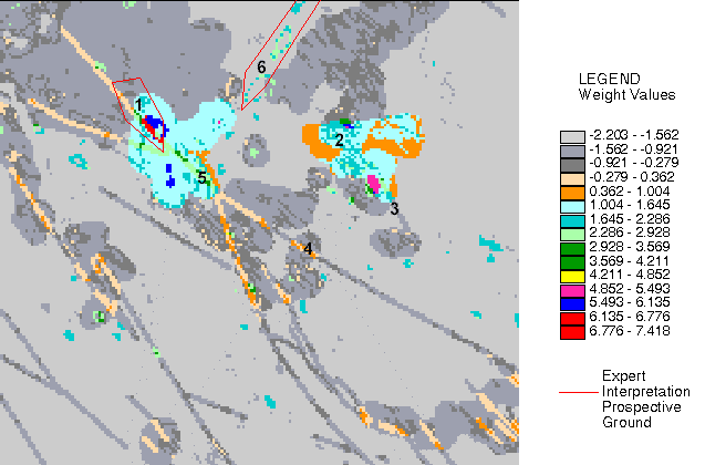
Figure 3. Prospectivity Map generated using the predictor data for the Mount Morgan area
Posterior probabilities, although calculated, were not used to interpret prospectivity for the Mount Morgan control area because the results obtained indicated a significant overall violation of conditional independence (CI). This is likely due to a number of factors:
- the identification of areas of mineralisation previously either not recognised or incorrectly identified in the training set;
- the effect of inconsistencies between the size of the mineralising system, the point location of known deposits, and the cell-size used for calculations; and or
- the violation of the assumption of conditional independence.
Discussions with government geologists suggested that a number of occurrences may be misclassified and are likely to be a part of a porphyry system. Considering the second point the problem here is caused by the definition used for porphyry type deposits. A better result could have been obtained by using a broader definition, such as porphyry systems which would include a number of specific deposit types in addition to skarns, for example epithermal vein deposits and replacement deposits. This point highlights the mechanics of ‘weights of evidence’ which assumes that each deposit is assigned to a unit cell area and does not specifically allow for the modelling for deposit systems. Conflict occurs because of the point location of occurrences and deposits, and the fact that a number of occurrences are often recorded in a porphyry system. This situation leads to the determination of a cell size that attempts a one on one ratio (cell:deposit/occurrence) and does not consider the areal extent of porphyry systems. The third point, violation of CI was reported by Agterberg (1992) as leading to posterior probabilities that are biased upward or downward. Subsequent work by Singer (in press) found that relationships between predictor variables, even when the correlation was considered not significant, caused the posterior probabilities to be biased predominantly upwards. The problem issue of upward bias, even where low correlations among the variables and where a relatively few are involved, lead to the use of weight rankings in this study to support (along with several other methods) estimates of the number of undiscovered deposits.
At this point in the resource assessment process, information has been produced on permissive and prospective ground.
Grade and Tonnage Models
The next stage in the USGS three-part methodology introduces grade and tonnage models which are later combined with estimates of the number of deposits to translate geologists’ resource assessments into economic terms (Singer and DeYoung, 1980; Singer and Mosier, 1983; Chung et al., 1990; Singer, 1993b). Grade and tonnage models are frequency distributions of tonnages and average grades of well-explored deposits of each deposit type. Singer (1993b) described grade and tonnage models and the issues associated with their construction (data problems – establishing cut-off grade, poorly known geology, need for consistency of the sampling unit, local variations to global models). Currently there are no comprehensive published grade and tonnage models focusing on Australian deposits. Whilst it could be presumed that undiscovered porphyry type copper deposits in eastern Queensland can be represented by the global grade and tonnage models, it is important to test the appropriateness of these models. To test the global models, comparisons are made with grades and tonnages of ‘local’ porphyry deposits. Local in this case refers to eastern Australia rather than the Yarrol region or central Queensland because of the small number of economic and sub-economic porphyry deposits known in Australia. Included in this grouping are deposits that are clearly of the Au-Cu type for example Cadia-Ridgeway located in northern New South Wales, and Red Dome, Mount Wright, Mount Success and Mount Leyshon in north Queensland. These have all been described as intrusive related Au breccia deposits, but they are also part of Au-Cu porphyry systems. Other examples include some that are described as Cu-Mo porphyry type such as Moonmera and Briggs which are located in the Yarrol study region, and just south of the study region is Mount Cannindah, a Cu-Mo deposit overprinted by later Au mineralisation. Deposit examples include some that are currently sub-economic and have either insufficient Cu-Au or fracturing to make an economic deposit or have not been thoroughly assessed by drilled. Cox and Singer (1986) showed typical porphyry deposits as having median grade and tonnage values for Cu-Mo systems of 0.42 percent copper and 500 Mt, for Cu systems of 0.54 percent Cu and 140 Mt, and for Cu-Au systems 0.5 percent Cu and 100 Mt. Porphyry type deposits in Queensland, such as Moonmera and Briggs have tonnages of about 100-200Mt with a Cu content commonly about 0.2 percent. Using a broader grouping of porphyry deposits ‘Cu-Au-Mo’ and including a range of deposits from eastern Australia, grade and tonnage distributions better approximate the USGS Cu and Cu-Au models. However, lower grade and tonnage values are still noted for median and tail-end members (median values at about 40 Mt and 0.3 percent Cu). In considering the local data, several issues needed to be recognised including the limited number of known deposits, the incomplete nature of resource records, and the use of immature grade and tonnage estimates from incompletely understood deposits. Estimations of the number of undiscovered deposits made in this work used the generalised ‘Cu-Au-Mo’ porphyry grade and tonnage models to better reflect the character of the local porphyry population.
Estimation of the Number of Undiscovered Deposits
The final stage of the resource assessment process applied in this study was the estimation of the number of undiscovered deposits. Estimates made reflected both the uncertainty of what may exist and a measure of the favourability for the existence of the deposit type. Following Singer (1993a) and Cox et al. (1996), estimates of this number were made at the 90th, 50th and 10th complementary percentiles as supported by evidence from three models. The first model was based on intense exploration and detailed geological knowledge that existed over the Mount Morgan control area. The assumption was made here that permissive ground in the well-explored Mount Morgan control area was typical in the number of deposits that could be expected within the permissive ground throughout the Yarrol. Following Root et al., (1992) a Poisson distribution was used to estimate the possible existence of 16 deposits in the Yarrol region. Singer (1993a) points out that the difference between the population of mineral deposits represented by a grade and tonnage model and the population of occurrences that may exist must be considered in the estimation of the number of undiscovered deposits. For estimates to be consistent with grade and tonnage models, approximately half of the deposits estimated should have greater than the median tonnage or grade. The estimates obtained were refined using local grade and tonnage information to suggest that there are 4 deposits in Yarrol with 100Mt Cu ore or greater.
The second model makes estimates based on the regional Government information available over the entire study region and on what was produced in the earlier prospectivity modelling stage. This approach was like the concept of ‘process constraints’ (Drew and Menzie, 1993), where the idea is that the more likely the combination of geological processes required for the formation of a deposit type, the more likely that deposit type should occur. This approach was considered to be more robust than the first model, in that it uses information from the entire region rather than extrapolating from a small control area. At the same time, it needs to be recognised that some deposits may be present that are not identified because of the modelling technique and or the information that was used. As target areas do not necessarily indicate the presence of an economic deposit Model 2 involved the development of rules by which the number of undiscovered deposits were estimated based on the number of targets identified. This follows the idea of counting and assigning probabilities to anomalies (Reed et al., 1989, Cox, 1993). Three rules were applied to the target numbers based on results from the Mount Morgan control area:
- targets in the top 10 percentile were assigned a 1:1 ratio to deposits;
- targets ranking in the top 20 percentile used a ratio based on the number of targets to known deposits in the control area; and
- for targets ranking above the 50 percentile, the generalisation used was that only one in ten systems is likely to be mineralised. Results obtained from prospectivity modelling of the Yarrol study area had two deposits ranking in the top 10 percentile (Mount Gordon and Moonmera).
A further three potential deposits were identified from the 20 percentile information, and by using targets generated from the 50 percentile, five potential deposits would be expected in the Yarrol study area. Based on this information an estimate of three deposits was made at the 50 percent confidence level and five deposits at the 10 percent level. Grade and tonnage data suggested that only one deposit was likely to be greater than 100Mt in size.
The third model used base-rate estimations from areas both favourable for the occurrence and well explored for porphyry copper deposits. Base-rate figures are used to set an upper limit reference value for estimates. Unlike Model 1, the areas used to generate density information are not directly associated with the study region and in this case come from studies made in the United States. Information for Nevada (Cox et al., 1996) and Arizona (Titley and Anthony, 1989) was used to make base-rate figures for porphyry occurrences. In the example from Nevada, a base-rate of 0.00015 porphyry deposits/km2 was used. Information from Arizona provided a base-rate of 0.0012 porphyry copper deposits/km2. Estimates for the Yarrol region, generated by applying base-rates to the area of permissive ground, are between 0.6 and 4.4.
Compilation of the results from the modelling, and verification by expert opinion gave the following final estimates for the number of undiscovered deposits the Yarrol region:
Table 1. Estimates of Undiscovered Deposits for the Yarrol Region
|
Yarrol Region |
Confidence level 90% |
Confidence level 50% |
Confidence level 10% |
|
Deposits |
– |
3 or more |
5 or more |
|
Deposits >100Mt |
– |
1 |
3 or more |
Estimates of the number of deposits greater than 100Mt reflected the greatest confidence in the results obtained from the combined input of prospectivity modelling and expert opinion. Examination of these estimations showed no deposits in the 90 percent confidence level and a relatively high number for between the 50 percent and 10 percent confidence levels. This suggested that, whilst there is limited confidence based on current knowledge of a deposit being present, there was evidence that the potential remains for 1 to 3 or 4 undiscovered deposits, greater than 100Mt, remaining in the area.
SECTION 3 – CONCLUSIONS
The Yarrol case study used quantitative resource assessment methodology to link a number of modern modelling techniques. This study found that Survey data would support quantitative analysis, identifying permissive and prospective ground, and where local grade and tonnage data was compiled, estimates of the number of undiscovered deposits. An important aspect of this work highlighted that the Survey needs to ensure that the types and formats of the data that it provides, effectively supports the types of data analysis that technological advances are introducing to its major client groups. By including computer-based prospectivity modelling and quantitative resource assessment as standard Survey procedures, along with the acquisition of geological data, new forms of data, auditing, and marketing tools are provided. Recommending the routine application of quantitative resource assessment by State Surveys leads to issues of implementation. Whilst the current study was able to apply a range of modelling processes as part of a quantitative resource assessment, there is considerable scope to improve product quality with better information management. Areas where continued work is required include: data collection, data quality, data format and access, and the processing of the data.
‘Weights of evidence’ was the technique used in the prospectivity modelling. It is worth highlighting that this technique, like other modelling techniques, has advantages and disadvantages. Two significant problems are:
- a tendency for posterior probability estimates to be upwardly biased, and
- the requirement for a representative training set. In this study, rank weightings were used instead of posterior probability estimates because of significant upward bias identified in the training set.
Considering the issue of having a representative training set is complicated because of the focus of exploration in Australia increasingly for deposits under cover. However, most of the known deposits available for training sets are examples of exposed occurrences. This leads to consideration of alternative or methods complimentary to ‘weights of evidence’. Agterberg et al, (1993) notes logistic regression’s ability to handle mutually interrelated variables and Singer (in press) similarly reports that the performance of neural networks can deal with correlated variables. There are, however, specific limitations associated with these alternative modelling techniques. Singer (in press) points out that logistic regression and neural networks cannot handle missing data and that they are also dependent on representative training sets. Geodynamic or ‘process’ modelling is an alternative approach that needs further investigation, particularly considering the focus on undiscovered deposits under cover. ‘Process’ modelling focuses on the potential for ore forming processes as dictated by material behaviour with changing forces, stresses, deformations, displacements, fluid flows, chemical reactions and thermal histories of rock masses (Ord, 1999). This approach could be considered as complementary to the techniques that focus on identifying patterns in data sets associated with ore deposits.
ACKNOWLEDGEMENTS
I wish to thank Donald Singer for providing data and advice used during the course of the Yarrol study and a pre-publication copy of his joint paper with Ryoichi Kouda ‘A Comparison of the Weights of Evidence Method and Probabilistic Neural Networks’. The contributions by the Graphical Services Unit, Queensland Department of Mines and Energy, and the staff employed by the Airdata Project GSO are acknowledged. Phil Burrows editorial improvements to this paper were gratefully accepted.
REFERENCES
Agterberg, F.P., 1992: Combining indicator patterns in weights of evidence modeling for resource evaluation. Nonrenewable Resources, 1(1), 39-50.
Allais, M., 1957: Method of appraising economic prospects of mining exploration over large territories-Algerian Sahara case study. Management Science, 3, 285-347.
Bliss, J.D., (Editor) 1992: Grade-tonnage and other models for diamond kimberlite pipes. Nonrenewable Resources, 1, 214-230.
Bliss, J.D., Menzie, W.D., Orris, G.J. and Page, N.J., 1987: Mineral deposit density – A useful tool for mineral-resource assessment. US Geological Survey Circular 995.
Chung, C.F., Singer, D.A. and Menzie, W.D., 1990: Size distributions for undiscovered mineral deposits. International Workshop on Statistical Prediction of Mineral Resources, China University of Geosciences, Wuhan, China.
Cox, D.P., 1993: Estimation of undiscovered deposits in quantitative mineral resource assessments: Examples from Venezuela and Puerto Rico. Nonrenewable Resources, 2, 82-91.
Cox, D.P. and Singer, D.A. (Editors), 1986: Mineral Deposit Models. US Geological Survey Bulletin 1693.
Cox, D.P., Williamson, A., Rogerson, R. and Finlayson, E.J., 1986: Mineral deposit models applicable to Papua New Guinea. Geological Survey of Papua New Guinea Report, 86-5.
Cox, D.P., Berger, B.R., Ludington, S., Moring, B.C., Sherlock, M.G., Singer, D.A. and Tingley, J.V., 1996: Delineation of mineral resource assessment tracts and estimation of number of undiscovered deposits in Nevada. Nevada Bureau of Mines and Geology Open-File Report, 96-2, 12/1-12/25 (also available at: www.nbmg.unr.edu/ofr962.).
Drew, L.J. and Menzie, W.D., 1993: Is there a metric for mineral deposit occurrence probabilities. Nonrenewable Resources, 2, 92-105.
Environmental Systems Research Institute, Inc, 1996: Arcview 3.0 Reference Manual.
Environmental Systems Research Institute, Inc, 1997: Spatial Analyst extension to Arcview 3.0 Reference Manual.
Fitzgerald and Associates, 1997: Intrepid Geophysical Processing, Visualisation and Interpretation Tools, Reference Manual, 3.
Grasty, R.L. and Minty, B.R.S., 1995: A guide to the technical specifications for airborne gamma-ray surveys. Australian Geological Survey Organisation, Record, 1995/20.
Horton, D.J., 1982: Porphyry type copper and molybdenum mineralisation in eastern Queensland. Geological Survey of Queensland Publication, 378.
Ord, A., 1999: A progress report on geodynamic modelling relevant to the formation and localisation of base metal mineralisation of the Mount Isa type. Workshop Presentation ‘Regional and Local Controls on the Formation of Mt Isa Type Base Metal Deposits’. Australian Institute of Geoscientists, Brisbane, (also available at: http://www.ned.dem.csiro.au/research/structure/).
Reed, B.L., Menzie, W.D., McDermott, M., Root, D.H., Scott, W. and Drew, L.J., 1989: Undiscovered lode tin resources of the Seward Peninsula, Alaska. Economic Geology, 84, 1936-47.
Root, D.H., Menzie, W.D. and Scott, W.A., 1992: Computer Monte Carlo simulation in quantitative resource estimation. Nonrenewable Resources, 1, 125-138.
Singer, D.A., 1993a: Basic concepts in three-part quantitative assessments of undiscovered mineral resources. Nonrenewable Resources, 2, 69-81.
Singer, D.A., 1993b: Development of grade and tonnage models for different deposit types. In Kirkham, R.V., Sinclair,W.D., Thorpe, R.I. and Duke, J.M. (Editors): Mineral Deposit Modelling. Geological Association of Canada Special Paper 40.
Singer, D.A. and DeYoung, J.H., 1980: What can grade-tonnage relationships really tell us? In Guillemin, C. and Lagny, P. (Editors): Resources minerale. Bureau de Recherches Geologiques et Minieres Memoire 106, 91-101.
Singer, D.A. and Kouda, R., 1996: Application of a feedforward neural network in the search for kuroko deposits in the Hokuroku District, Japan. Mathematical Geology, 28, 1017-1023.
Singer, D.A. and Kouda, R., 1997: Classification of mineral deposits into types using mineralogy with a probabilistic neural network. Nonrenewable Resources, 6, 27-32.
Singer, D.A. and Kouda, R., (in press): A comparison of the weights of evidence method and probabilistic neural networks. Nonrenewable Resources.
Singer, D.A. and MacKevett, E.M., 1977: Mineral resources map of the McCarthy quadrangle, Alaska. US Geological Survey Miscellaneous Field Studies Map, MF 773-C, 1 sheet, scale 1:250000.
Singer, D.A. and Mosier, D.L., 1981: The relationship between exploration economics and the characteristics of mineral deposits. In Ramsay, J.B. (Editor): The economics of exploration for energy resources. Greenwhich Conneticutt, JAI Press, 313-326.
Titley, S.R. and Anthony, E.Y., 1989: Laramide mineral deposits in Arizona. In Jenney, J.P. and Reynolds, S.J. (Editors): Geologic Evolution of Arizona: Tucson. Arizona Geological Society Digest, 17, 485-514.
Endnotes
[1] Geodynamic process modelling is can alternative to approaches which focus on evidence of mineralisation, considering the potential for ore forming processes as dictated by analysis of material behaviour with changing forces, stresses, deformations, displacements, fluid flows, chemical reactions and thermal histories of rock masses.
[2] The distinction is significant with a deposit defined as a concentration of mineral of sufficient size and quality that it might, under the most favourable circumstances, be considered to have economic potential (Cox et al., 1986).
[3] Exceptions to the exploration model do occur, for example Ridler Creek is an occurrence in the Yarrol region that is reported as a porphyry style mineralisation in nepheline syenite of probable resources. For Australian Surveys this process also serves as an audit of data sets aimed at impacting on the principal client group, the exploration industry, and provides an output that can be applied to the marketing of State resources. This section briefly introduces the modelling technique ‘weights of evidence’ and discusses its application to the Mount Morgan control and Yarrol data sets including the development of the exploration or conceptual model for porphyry type copper deposits Cretaceous age and derivation of predictor or factor maps. The problem of ‘exceptions to the rule’ is not addressed in prospectivity modelling, but by adopting a broad definition for permissive ground.
Received: October 1999
Published: April 2000
AIG Journal Paper 2000-02, April 2000