P.M. Jayawardhana, M.I.M. Exploration Pty Ltd
Click here to download paper as PDF
ABSTRACT
Over the last five years M.I.M. Exploration (MIMEX) has focused on developing a spatial data management system that enables the visualisation and analysis of data at the area of operation. It allows up-to-date information to be in the hands of the decision makers around the world. This has been a major turn around and re-think from the days of centralised data management.
This paper highlights some of the advantages and disadvantages of decentralised GIS from a M.I.M. (Mount Isa Mines) perspective and what the future holds. We are living in exciting times of constant change, which require our systems to be adaptable to all conditions and environments. The challenge of the 21st Century is to harness technology to work for us and not against us, enabling us to work more efficiently and effectively, without impacting on our overall lifestyle.
INTRODUCTION
MIMEX entered the GIS world in early 1992, when it started looking at MapInfo[1] as a tool for mineral exploration. This began in Mount Isa on a small scale trial. In early 1993, MIMEX moved to Brisbane and an R & D (Research and Development) project was established to develop a GIS and look into the benefits of using GIS in mineral exploration in the Mount Isa Inlier. As part of the R & D project MIMEX employed a GIS specialist. After the early trial in 1992 MIMEX had decided that MapInfo was not capable of providing what was required and Arc/Info[2] would be better suited to the job, however popular demand over the last few years has turned the focus back to MapInfo.
DISCUSSION
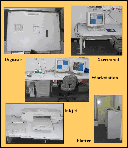
In early 1993 the aim was to design and implement a centralised GIS to aid exploration efforts in the Mount Isa Inlier (Figure 1). As can be seen from Figure 1, the location of the centralised GIS was in the Brisbane office, 1600 km from the study area. In terms of hardware, a Sun SPARC10 (64 Mb RAM and 4 Gb disk space) and a Hewlett Packard Xterminal were purchased. Peripheral equipment included SumaGraphics A0 digitizer, Hewlett Packard Draftmaster pen plotter, and Hewlett Packard XL300 inkjet plotter (Figure 2). The software was a three node locked license of UNIX Arc/Info, one license of Grid, and one license of TIN. The total equipment and software startup cost was approximately A$80,000.
Figure 1. GIS study area in 1993 (Centralised GIS)
Figure 2. Collage of the GIS infrastructure
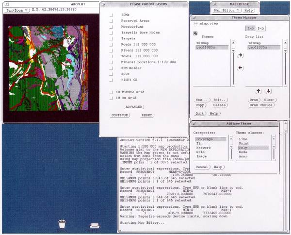
During late 1993 and 1994 major resources were spent acquiring and generating digital data for the study area. Once sufficient digital information was available the focus changed to developing user friendly front ends to the GIS to make it easy for Explorationists to access information and produce maps. In 1995 the Map Production System was developed which allowed Explorationists to produce up-to-date tenement maps for any part of Queensland (Figure 3). They could also add any other information available in the GIS (e.g. geology, roads, rivers, etc.) onto these maps at a press of a button.
Figure 3. Map Production System screen shot
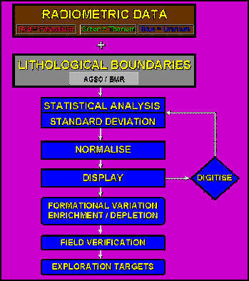
During the later part of 1995 time was also spent developing analytical and spatial modelling components to the GIS (Jayawardhana and Sheard, 1997) (Figure 4). Monthly, tenement change detection, competitor monitoring and target monitoring products were also made available. These techniques and products took GIS beyond being just a data visualisation and data integration tool and enabled GIS to provide invaluable information in helping MIMEX geoscientists better understand the complex environments in which they work.
Figure 4. Flow chart of spatial modelling procedure using GIS
In February 1996, MIMEX reviewed the GIS R & D project and its achievements and concluded that GIS was a very useful tool in mineral exploration and should be expanded. Though extremely positive in its outcome the review brought some very difficult questions: how would we implement a centralised GIS in a company which spans the globe? How could MIMEX provide GIS hardware, software and support in a company whose budget was continually diminishing? What people resources was MIMEX willing to contribute to a GIS expansion?
In answering these questions M.I.M. moved into a new phase of data awareness.
The implementation plan was to use Arc/Info as the centralised GIS and have ArcView2 at all of the offices around the world. ArcView would then be the GUI (Graphic User Interface) to the GIS data and MIMEX would customise this environment to the needs of the users.
To deal with the question of cost, the plan was to keep the GIS infrastructure as simple as possible. Again ArcView on a Personal Computer (PC) platform was the ideal interface and MIMEX approached ESRI2 for a very cost effective deal to cover all operations around the world.
Though M.I.M. wanted to see GIS expand to 15 different offices around the world they were not prepared to see GIS support staff increase from one. For GIS to succeed, global operations had to be structured relying heavily on the existing personnel and resources at each of the offices. The GIS had to also be useable and ‘owned’ by Explorationists and not GIS experts. This also meant a comprehensive training and education program to elevate the knowledge and awareness of the value and usefulness of GIS as a mineral exploration tool.
In late 1996 cracks began to appear in the grand plan. The ArcView 2 release had been delayed and we were not going to see a stable and useable version of ArcView enter the market place till 1997. This was a major blow to our overall plan as everything was hinged on getting ArcView and customising it to suit the needs of our offices around the world. As the mining industry is never one to wait, sites, which wanted to use GIS, started to purchase MapInfo as an interim solution. MapInfo had come a long way from the package that was baselined in 1992.
The start of 1997 saw M.I.M. straddling two GISs (Arc/Info-ArcView and MapInfo). This was a very difficult period as technical support and data management were still only provided by one individual. In mid 1997, the user friendly nature of MapInfo had won overwhelming support from MIMEX geoscientists and M.I.M. made the strategic discussion to use MapInfo as its main GIS, and Arc/Info-ArcView would be used in the background in Brisbane. This decision was a major turning point. Implementation of GIS into all of M.I.M’s Exploration offices began, with the aim of being completed by mid 1998.
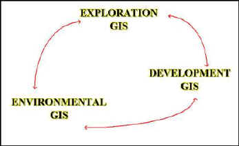
Around the same time as MIMEX started implementation of GIS globally, GIS was introduced into M.I.M.’s Environmental operations at Mount Isa Mine and the implementation of a decentralised GIS which supported all M.I.M. operations had started. GIS was evolving from a centralised system used by MIMEX to a decentralised tool used beyond just exploration, but rather, in the full circle of M.I.M.’s operations. The digital data generated at the exploration stage could be passed on and used in the production and environmental management stages of operation (Figure 5). As shown in Figure 6, this enables a two way flow of information, which would aid all aspects of M.I.M.’s operations.
Figure 5. M.I.M.’s GIS strategy
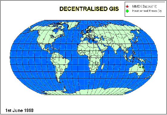
The beginning of 1998 saw M.I.M.’s commitment to GIS expand to a new height. MIMEX brokered a very unique global deal with MapInfo Australia enabling centralised licensing and decentralised operations. This opened the doors for the global expansion of GIS to all areas of operation (Figure 6). The new study area as shown in Figure 6, was a far cry from the original shown in Figure 1. Decentralised GIS was now expanding to 11 exploration offices and 9 environmental offices around the world. Implementation of GIS into M.I.M.’s environmental offices started in early 1998, with the aim of being completed by the end of 1998.
Figure 6. GIS study area in 1998 (Decentralised GIS)
M.I.M.’s approach to GIS has been very unique in two ways. The first, is that it is one of the few mining companies in the World that is using GIS throughout the full circle of its operations (Table 1). This has enormous benefits in terms of data management, cost savings and better utilisation of the available information. In 1998/99 MIMEX spent approximately eighteen million dollars on capturing and acquiring digital data. At least six percent of this data was past down the line to development and environment, equating to a cost saving of around 1 million dollars to the M.I.M. group. GIS has also provided a uniform data format for transfer of digital spatial data throughout the M.I.M. group. The second, is that at present M.I.M. has not allocated people to manage and support the decentralised GIS at each site, and this is an area which will need attention in the future.
Table 1. GIS in the mining industry.
|
Company |
Exploration Budget ($M) |
GIS in Exploration |
GIS in Development |
GIS in Environment |
GIS data flow |
|
Anglo-American |
|
3 |
8 |
8 |
8 |
|
BHP |
9 |
3 |
Some |
Some |
8 |
|
MIM |
22 |
3 |
3 |
3 |
3 |
|
North |
50 |
3 |
8 |
Some |
8 |
|
Pasminco |
17 |
3 |
Some |
Some |
8 |
|
Placer |
86 |
3 |
8 |
Some |
8 |
|
RTZ |
120 |
3 |
Some |
8 |
8 |
|
WMC |
50 |
3 |
8 |
Some |
8 |
(Industry sources, June 1998).
Even with the limited personnel, implementation of GIS into M.I.M.’s exploration offices was completed ahead of schedule. An ongoing education and training program is underway to develop in-house GIS expertise at each office by the end of 1999.
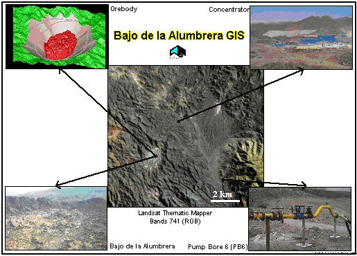
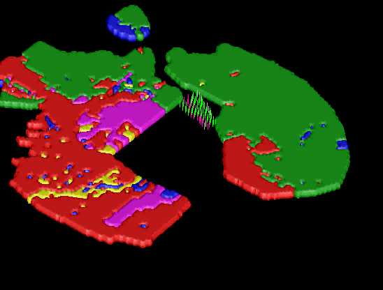
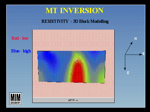
As we rocket forward into the 21st Century, there are many challenges that lie ahead. One of the greatest challenges confronting GIS is the ability to integrate information from different packages and applications (Figure 7). At present M.I.M. is working towards making all of its applications software integratable with GIS. The aim is to be able to feed information into the GIS from the plethora of in-house and off-the-shelf applications packages. This is progressing very well at present with a number of strategic alliances already being forged with a number of applications developers to ensure that Geophysical, Geological and Geochemical information can be passed directly to the GIS from the generic applications software. Two areas where M.I.M. is looking to improving integration is in orebody modelling (Figure 8) and geophysical modelling (Figure 9).
Figure 7. Using GIS for data integration
Figure 8. Orebody Modelling
Figure 9. Geophysical modelling
New technologies in regards to satellite phones and worldwide differential Global Positioning Systems (GPS) are revolutionising the way we work. We can collect information to a positional accuracy of ±5m anywhere in the world and have this information emailed via satellite phone to any office in the world from the field. New geophysical techniques and equipment are letting us look for minerals much deeper and enabling us to re-explore old areas with greater vigor.
Parallel to the development and implementation of GIS throughout M.I.M. has been an education program to highlight the importance and value of digital data. MIMEX has finally acknowledged that it spends millions of dollars on capturing digital data and very little (<1%) on cataloguing, archiving and preserving this data for future use. This trend is slowly changing with the introduction of a Spatial Data Management System at all MIMEX offices and a centralised Archive and Spatial Data Index. The Spatial Data Management System is a directory tree structure with file level indexing developed and maintained at the base. Each MIMEX office around the world follows the same general structure and only minor modifications are necessary depending on the application packages used at the base. The Archive and Spatial Data Index is a system to copy and archive all digital data purchased, acquired and captured by MIMEX throughout the world. The overall index is written to CD every six months and circulated to all Exploration offices. The metadata associated with each dataset is recorded and made available through a GIS interface and database interface. The Spatial Data Management System and Archive and Spatial Data Index work hand in hand with GIS. These two systems are fundamental for the management and accessibility of MIMEX’s extensive digital data archive (> 20 Terrabytes).
Conclusions
Over the last five years M.I.M. has changed GISs from Arc/Info-ArcView to MapInfo and changed it’s focus from a centralised GIS to a decentralised GIS. Both these decisions have been made due to the needs of the users. This willingness to listen to what the users want and need, has placed M.I.M. in a very unique and united position to greet the beginning of the new millennium.
As M.I.M. moves forward into the future the three key areas to success will come from integration, data management and new technology. M.I.M. is forging ahead in all three areas which is resulting in improved data analysis and interpretation. It will only be through the ability to pull information from different specialist applications into one cohesive system (GIS) that M.I.M. will be able to maximise the wealth of information that is available. At present three quarters of the applications packages used by MIMEX can be integrated directly into GIS. In the future all applications packages will provide information to the GIS.
Data management is slowly being elevated from a behind the scenes requirement to a very important aspect of our day to day work. Without access to the best quality data and the metadata associated with this information Explorationists can make ill informed decisions with expensive consequences. Surprisingly enough, data management has received the least support in the past. In today’s digital world it is imperative we rectify this shortsightedness as the increasing volumes of digital data collected today, if not managed at the point of capture, will be impossible to find as time goes on.
New technologies in regards to satellite phones and worldwide differential Global Positioning Systems (GPS) are revolutionising the way M.I.M. operates in this ever shrinking world. New geophysical techniques and equipment are letting us look for minerals much deeper and enabling us to re-explore old areas with greater vigor.
In today’s world of high technology (WWW, internet, email, etc.) and the ease of travel (anywhere in the world in a day), one would expect we would have more time to pursue interests other than work. Unfortunately, the opposite is true. Though technology has improved we seem to work longer hours and are required to travel to all parts of the globe. The constant restructuring and downsizing of companies means that those remaining have to work harder to try and diminish an ever growing workload. The challenge of the 21st Century will be to find a balance. In M.I.M’s world there is an office working somewhere every hour of the day and we need to harness the technology to ensure we can support these operation with out having to work 24 hours a day.
REFERENCES
Jayawardhana, P.M., and Sheard, S.N., (1997). The Use of Airborne Gamma Ray Spectrometry by M.I.M. Exploration – A case study from the Mount Isa Inlier, North West Queensland, Australia. In: Proceedings of Exploration 1997 – Geophysics and Geochemistry at the Millenium – the Fourth Decennial International Conference on Mineral Exploration. Prospectors and Developers Association of Canada.
[1] MapInfo is the registered trade mark of MapInfo Corporation, New York, USA.
[2] Arc/Info, ArcView and ESRI are registered trade marks of Environmental Systems Research Institute, Redlands, USA.
Received: October 1999
Published: April 2000
AIG Journal Paper 2000-04, April 2000
