
Ian Morrison1 and Joe Treacy2
1Lantana Exploration Pty Ltd, 2Kagara Zinc Ltd
Click here to download paper as PDF
Introduction
Kagara Zinc Limited is currently undertaking a programme of detailed infill and ore delineation drilling at the Mt Garnet zinc skarn deposit. A feasibility study will then be completed to assess the viability of mining. If successful, development should commence within 12 months.
The global resource currently stands at 3.94 Mt at a grade of 6.5% ZnE (Zinc Equivalent) calculated at 3% ZnE cut-off; measured and indicated resources comprise roughly 65% of this global resource (Kagara Zinc Ltd prospectus, 1999). The current drilling programme has revealed high grade mineralisation below the previously interpreted base of the orebody which will add substantially to the resource. It is expected that re-optimisation of the planned open pit will include a substantial amount of this ore.
Location and Infrastructure
Mt Garnet is located in North Queensland on the southern edge of the Atherton Tableland, about 105 kilometres south-west of Cairns and 350 kilometres north-west of Townsville. The deposit crops out about one kilometre south of Mt Garnet township. Mining Lease ML20016, which covers the orebody and immediate environs, is a Freehold Tenement.
Mt Garnet is serviced by sealed roads and grid power. Alluvial tin mining in the area has left a legacy of several large water storages. The region has a long mining history and will provide an experienced workforce. It is expected that concentrate will be transported to the recently commissioned Sun Metals’ zinc refinery in Townsville.
Mining and Exploration History
The Mt Garnet area has had a long and colourful mining history. It was one of the many townships established on the Atherton Tableland to service the flourishing tin industry in the late 19th Century. Alluvial and eluvial tin mining in the Mt Garnet area provided most of the tin production in the region from the 1930’s through to the early 1980’s (Donchak and Bultitude, 1998).
The Mt Garnet Freehold Copper and Silver Mining Company Limited started mining copper from the Mt Garnet deposit in 1898, and began smelting ore on site in 1901. They ceased operations in 1902 when the oxide and supergene copper ore had been exhausted, and the ore graded into sphalerite-rich primary sulphides (Kagara Zinc Ltd prospectus, 1999). Chillagoe Railways and Mines Limited continued tribute mining through 1903 and 1904. Ore was largely derived from the No 1 Pit (South Pit), with minor production from the No 2 Pit (North Pit), located about 150 metres to the north. Underground development extended to roughly 90 metres below the surface, with only very limited stoping and production (Main, 1987).
During the period of 1898 to 1904, approximately 99,000 tonnes of ore was treated at an average grade of 4.9% copper, 325 g/t silver and roughly 4 to 7% zinc. The zinc was not recovered and remains in the old slag heap; there was neither the demand for the metal nor the technical capacity to recover it (Kagara Zinc Ltd prospectus, 1999).
From 1915 to 1917 an unsuccessful trial zinc production operation was undertaken from the underground workings. In 1926, 960 odd tonnes of oxidised lead ore was extracted from the Northern Lead Workings, located along strike and 300 metres north of No 1 Pit (Main, 1987). In 1946 and 1947, Zinc Corporation Limited (progenitor of CRA) tested the orebody with five core holes and, in 1956, Metals Exploration drilled one core hole. Between 1971 and 1984, CRA pursued a syngenetic stratiform model and completed extensive mapping, trenching, ground and airborne magnetics surveys, and soil geochemistry. In 1974 they completed 3 deep core holes at roughly 200 metre intervals along the then interpreted strike length of the orebody. The southernmost of these intersected significant zinc mineralisation in the still poorly defined southern shoot, located about 200 metres south of the main orebody (Main, 1987).
The project was acquired by Perilya Mines NL in 1989 and, between 1989 and 1991, they managed the project on behalf of various joint venture partners. During this period they completed 50 core holes (mostly pre-collared) and 12 RC percussion holes, mostly targeted on the interpreted orebody. Preliminary metallurgical and mining studies, and baseline environmental studies, were also undertaken.
Kagara’s Involvement
In November, 1998, Kagara entered into an agreement with Perilya giving Kagara the exclusive right to earn up to a 75% interest in the Mt Garnet zinc skarn deposit, and the Walsh River tenements located north-west of Chillagoe. Following an over-subscribed public issue of shares, Kagara was listed on the ASX in December, 1999.
Current Programme
Kagara has embarked on a 10,000 metre programme of detailed infill and ore delineation drilling, initiated definitive metallurgical testing of the ore, commenced preliminary mining studies, and re-commenced environmental monitoring.
At the time of writing (18th March, 2000), ore delineation drilling, targeted nominally 25 to 50 metres below the interpreted base of open-pittable ore-grade mineralisation, has returned highly encouraging results from two drill holes located 40 metres apart along strike. These include 19 metres grading 7.5% zinc in GTD53, and 17.35 metres grading 6.0% zinc in hole GTD56. Although resource figures have not been re-calculated, it is expected that the planned open pit will be re-optimised to include this mineralisation. The current drilling has led to a reinterpretation of the attitude of the mineralisation, and these high grade intercepts may define the top of a previously unrecognised high grade ore shoot (Figure 1). This interpretation will be tested by further drilling.
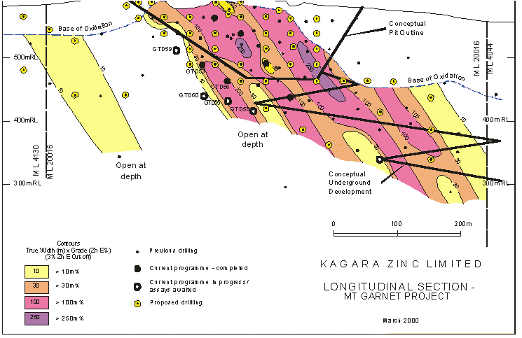 Figure 1. Kagara Project Longitudinal Section
Regional and Local Geological Setting
The Mt Garnet zinc skarn deposit lies at the southern end of the exposed limit of the Siluro-Devonian Chillagoe Formation. The formation comprises limestones, cherts, mafic volcanics and clastic sedimentary rocks, and occupies a narrow belt, up to 10 kilometres wide, along the western margin of the extensive Siluro-Devonian Hodgkinson Province. This belt trends north-westerly for about 150 kilometres from Mt Garnet, and then northerly for a further 150 kilometres. Mineralisation within the Chillagoe Formation includes skarn, porphyry and possible Besshi-style deposits.
Along most of the strike-length of the Chillagoe Formation, the western boundary is delimited by the mylonitic Palmerville Fault along which Siluro-Devonian rocks to the east have been juxtaposed against Proterozoic schists and gneisses to the west. The relationship in the Mt Garnet area is more complex, with a fault bounded inlier of interpreted Proterozoic rocks located immediately to the east of the Chillagoe Formation and the Mt Garnet deposit. Further compression during the Carboniferous produced open to tight mesoscopic to large-scale folds (Donchak and Bultitude, 1998). Permo-Carboniferous terrestrial felsic-dominant volcanics and granitoids are regionally extensive. There are isolated remnants of Mesozoic sedimentary rocks in the region.
The Palmerville Fault is considered to have been re-activated as a major west-over- east thrust fault during the Late Devonian to Early Carboniferous during a compressional deformation phase. In the Chillagoe region, extensive thrust faulting within the Chillagoe Formation is sub-parallel to the Palmerville Fault and has dissected the formation into a series of westerly-younging imbricate thrust slices within a regionally easterly younging environment (Donchak and Bultitude, 1998).
In contrast, the relationship between the Chillagoe Formation, Proterozoic rocks and the Palmerville Fault in the Mt Garnet area is problematical. A mylonitic fault bounded inlier of possible Proterozoic schists and gneisses lies immediately to the east of the Mt Garnet zinc deposit. Graded bedding in arkosic sediments immediately west of the calc-silicate horizon indicates that eastwards younging Chillagoe Formation underlies Proterozoic rocks to the east. Donchak and Bultitude (1998) resolved this architecture by invoking local development of a roof thrust along the Palmerville Fault. Venn (1985) suggested that subsequent folding of the thrust surface, the underlying Chillagoe Formation and overlying Proterozoic rocks is consistent with the location of the Mt Garnet zinc deposit on the eastern limb of an anticline.
Host and Wall Rocks
The Mt garnet zinc skarn deposit is hosted by a vertically-dipping skarn horizon that locally exceeds 50 metres thick and has a mapped strike length of about 800 metres (Hartley and Williamson, 1995). Wall rocks comprise arkose to the west and mylonite to the east.
Arkose
To the west, an eastwards younging thin- to thick-bedded arkosic unit, comprising siltstones, sandstones, grits and conglomerates, conformably underlies the skarn-altered horizon. Mylonitic clasts occur in the conglomerate beds (Venn, 1985; Hartley and Williamson, 1995) indicating the arkosic sandstone was, at least in part, derived from intensely deformed rocks that pre-date the Siluro-Devonian Chillagoe Formation and the Late Devonian/Early Carboniferous thrusting. Rare fine-grained beds with coralline fossils occur up to several tens of metres west of the skarn horizon. The arkose is typically highly silicified and locally cut by narrow (centimeter-scale) shear bands. Skarn veins and replacement zones, ranging up to several tens of centimetres thick, are common for several metres beyond the skarn horizon contact. Locally, these veins are highly mineralised.
Mylonite
To the east, the skarn-altered horizon is in contact with a zone of intensely foliated and mylonitic rocks that commonly exceeds 20 metres in thickness. Further to the east lie highly foliated ?Proterozoic-age mafic rocks and gneissic granite. The mylonite is typically highly siliceous, with evidence for both pre- and post-deformation silicification. Locally, immediately adjacent to the skarn, mylonite appears to be gradational into fine-grained clastic sediments, suggesting the mylonite protolith may partly comprise Chillagoe Formation sediments. Skarn veins cross-cut the mylonitic fabric and are common for several metres into the mylonite.
Skarn Protolith
Hartley and Williamson (1995) suggested the skarn protolith was probably an interbedded, fossiliferous limestone and calcareous mudstone sequence, and they note the presence of relatively unaltered small patches of residual limestone and marl outcrops at the northern end of the skarn exposure. Drill core intercepts away from the most intense skarn alteration also reveal the presence of patchy to weakly pervasive skarn-altered interbedded and silicified, variably fossiliferous and commonly arkosic sediments. This suggests that the skarn horizon does not represent alteration of a discrete limestone-dominant unit but, rather, suggests that the altered protolith was characterised by a rapid gradational increase in calcareous beds at the top of the arkose package. Crude layering in the skarn horizon probably represents relict bedding and foliation. In general, layering intensity increases towards the mylonite, and deformation of fossils is more pronounced adjacent to the mylonite contact. Alteration and mineralisation clearly post-date the mylonitic fabric.
Alteration and Mineralisation
Alteration
Skarn alteration is characterised by prograde and retrograde assemblages.
- Prograde alteration is dominated by garnet (andradite) and clinopyroxene with appreciable vesuvianite and calcite, and minor wollastonite.
- Retrograde alteration is particularly associated with sulphide/magnetite mineralisation and includes pervasive, vein-style and breccia matrix amphibole, calcite, chlorite, epidote and hydrogrossular (RN England, pers. comm.). In particular, prograde garnet is typically calcite-epidote-altered; clinopyroxene is typically chlorite-amphibole-calcite altered.
Mineralisation
The dominant ore minerals include sphalerite (marmatite), magnetite and pyrrhotite, typically with minor chalcopyrite and pyrite, and traces of galena. Locally, chalcopyrite is the dominant sulphide. Silver values are typically around 20 to 30 g/t, but locally exceed 1,000 g/t. Arsenic only rarely exceeds 50 ppm. Chisholm and Baxter (1990) reported elevated tin (to 0.33%) and tungsten (to 0.1%) in rock chip samples collected in the orebody environs.
Sphalerite, along with other mineralisation phases and retrograde alteration phases, occurs as fine to coarse and clotty disseminations, commonly concentrated along ragged, discontinuous bands or concentrated in the matrix of locally extensive breccia zones; also in veinlets and veins, patchy replacements and bands of massive replacement over one metre thick. Selective replacement of coralline fossils (?crinoid stems) by any of the main sulphide phases and magnetite is characteristic. Crosscutting relationships reveal a multi-phase alteration/mineralisation event.
The main ore-types, characterised by associated sulphide phases and magnetite, are:
- Sphalerite-dominant ore, typically with only very minor amounts of other sulphides and magnetite
- Pyrrhotite-dominant sphalerite ore, commonly with minor to moderate chalcopyrite and generally only minor magnetite
- Magnetite-dominant sphalerite ore, locally with appreciable pyrrhotite and chalcopyrite
- Chalcopyrite-sphalerite ore, commonly with appreciable pyrrhotite – copper grades may exceed zinc grades
Paragenesis
The paragenesis story is evolving, but early observations suggest the following deformation/alteration/mineralisation sequence:
- Early silicification: possibly pre-, syn- and post-thrust faulting during the Late Devonian to Early Carboniferous
- Prograde skarn alteration: dominated by garnet and clinopyroxene alteration of the variably calcareous and fossiliferous sediments and arkose
- Early magnetite alteration with local brecciation: typically fine-grained and concentrated along discrete ragged layers, locally massive, locally concentrated within breccia matrix
- Sulphides with late magnetite and retrograde alteration assemblages, locally accompanied by weak to intense brecciation
- Late-stage amphibole-calcite-hydrogarnet veins, commonly with appreciable sulphides
- Late pyrite-calcite veinlets
The Orebody
The orebody, defined at a 3% ZnE cut-off, has a strike length of about 400 metres and occurs as one or more steeply-dipping zones ranging from two to 23 metres wide, generally occupying the central portion of the skarn horizon.
Until the current programme of detailed delineation and infill drilling, the body was interpreted as having a northerly plunge of around 30 degrees. However, substantial widths of ore-grade mineralisation intersected during the current programme, up to 50 metres below the previously interpreted base of the body, suggest the body may plunge more steeply to the north at around 55 degrees, and may consist of a series of high-grade shoots separated by narrow lower-grade zones (Figure 1). Continuing drilling will test this interpretation. A poorly defined mineralised zone, located about 200 metres south of the orebody and referred to as the South Shoot, appears to also plunge to the north (Figure 1).
The base of oxidation varies from around 15 to 20 metres in the southern (open-pittable) half of the deposit, increasing to 100 metres deep over the northern part. Increased drill density will refine this boundary.
Resource estimates completed by Resource Service Group (Ridley, 1999) using cut ordinary kriged zinc and copper estimates for the interpreted region of the skarn horizon with greater than 3% ZnE, and cut inverse distance squared estimates for the remaining region of the skarn, produced the following resource estimates:
- Measured Resource 0.47 mt at 6.70% Zn and 0.47 mt at 0.42% Cu
- Indicated Resource 2.02 mt at 6.40% Zn and 2.01 mt at 0.33% Cu
- Inferred Resource 1.45 mt at 5.20% Zn and 1.40 mt at 0.33% Cu
- Total Resource 3.94 mt at 6.00% Zn and 3.88 mt at 0.34% Cu
References
Chisholm, J.M. and Baxter, J.L., 1990. Mt Garnet Project Far North Queensland. Internal company report prepared by Continental Resource Management Pty Ltd. for Falcona Exploration and Mining NL.
Donchak, P.J.T. and Bultitude, R.J., 1998. Queensland 1:250 000 Geological Series Explanatory Notes to accompany Atherton 1:250 000 Geological Map, Sheet SE 55-5. Dept of Mines and Energy Geological Survey of Queensland.
Hartley, J.S. and Williamson, G., 1995. Mount Garnet zinc rich skarn. In: Mineral Deposits of Northeast Queensland: Geology and Geochemistry, Ed: S.D. Beams. EGRU Contribution 52: 239-243.
Kagara Zinc Limited, 1999. Prospectus.
Main, J., 1987. Mt Garnet Leases. CRA Exploration Pty Ltd. Internal report.
Ridley, J., 1999. Mt Garnet Project Database Validation, Statistical Analysis and Resource Estimation. Prepared by: Resource Service Group for Kagara Zinc Limited.
Venn, P.J., 1985. Evidence of Thrusting and Subsequent Genesis of Cu-Zn-Ag (Pb) Skarn Deposit with Tin Affinities, Mount Garnet, North Queensland. Unpublished Honours Thesis, James Cook University of North Queensland.
Received: March 2000
Published: Jan 2001
AIG Journal Paper 2001-05, Jan 2001